


Természetjáró, a túratervező
Természetjáró, a túratervező介绍
匈牙利在线旅游指南,专为徒步旅行者、骑自行车的人、越野跑者、攀岩者和水上运动爱好者开发,具有内置的旅游规划器,以及数百条推荐的旅游路线和数千个景点,均配有详细的描述和大量的照片,在交互式地图上轻松查看。免费提供,并提供扩展功能的订阅选项。
功能
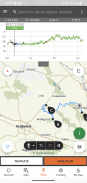
• 各种交互式、可缩放、矢量化全球远足地图,其中包含所有标记的路线,显示您当前的位置
• 在地图上规划您自己的游览的便捷方式,并立即获取长度、持续时间和海拔剖面图
• 为徒步旅行者、骑自行车者、越野跑者和划独木舟者推荐的上千条旅游路线,提供实用数据、附近最佳景点的详细描述、自然和文化背景、高质量照片以及如何到达那里的信息
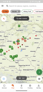
• 匈牙利数以千计的推荐景点,包括了望塔、自然全景点、森林火车、堡垒和博物馆,并附有详细的描述、高质量的照片以及如何到达这些景点的信息
• 数百个住宿,包括小屋、旅游酒店和公寓,靠近有标记的小径
• 有用的收藏(带地图视图):巴拉顿湖周围的海滩、滑冰场、植物园、最佳越野跑路线、攀岩场所、残疾人旅游路线等。
• 通知、警告和关闭
• 下载地图部分、游览和景点供离线使用
• 沿路线进行动态导航,提供实时海拔剖面图和语音指令
• 记录您的路线
• BuddyBeacon:与好友实时分享您的位置
• 完整的匈牙利蓝色之旅,包含官方路段和路线、兴趣点和住宿
• 在运行应用程序的计算机和移动设备之间同步您的所有内容
• 查看当地天气预报
• 3D 飞行:旅游的虚拟鸟瞰图
• 内置有用的工具,例如峰值查找器(Skyline)和指南针以及您当前的位置
• 社区服务:与您的朋友评价和分享内容
搭载 Google WEAR OS 的智能手表
只需看一眼您的智能手表,即可获得有关您在地图上的 GPS 位置的信息。您可以记录轨迹、获取跟踪数据并沿路线导航。使用应用程序图块可以轻松访问附近的路线。
专业会员专享
去任何地方:Outdooractive Pro 可以离线工作,无需移动和数据信号。还可以创建无限列表,并且该应用程序没有广告。此外,您还可以查看卫星图像、包含 30 多个活动路线网络的独特 Outdooractive 地图以及来自以下提供商的官方地形图:
英国军械测量局、Landranger、Explorer
新西兰土地信息
犹他州美国地质勘探局
德国BKG
奥地利纯电动汽车
瑞士 swisstopo
法国IGN
西班牙CNIG
意大利
荷兰PDOK
挪威赛车手
丹麦 Kortforsyningen
瑞典兰特玛特瑞特
芬兰国家土地调查
日本GSI
全球地图
Pro+ 会员专享
Pro+ 还包含来自 Alpine Associations 的官方地图以及来自 KOMPASS 的高级地图。
如果您有疑问或建议,请访问
https://www.termeszetjaro.hu/hu/p/gyakran-ismetelt-kerdesek/41050512 /
我们的桌面版本:
https://www.termeszetjaro.hu/
在 Facebook 上关注我们:
https://www.facebook.com/Termeszetjaro.hu/
联系我们:
termeszetjaro@termeszetjaro.hu
有关 TEKA 卡的更多信息:
http://www.termeszetjarokartya.hu/
Természetjáró, a túratervező - APK信息
APK版本: 3.19.4程序包: com.outdooractive.mtszTermészetjáró, a túratervező的最新版本
其他版本


同类应用


